

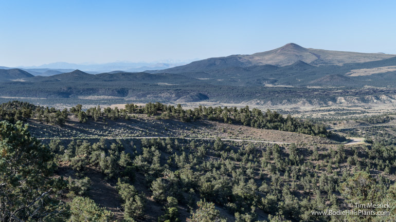
Looking Northwest from Lucky Boy Pass: Corey Peak
in the southern Wassuk Range
The earliest map I’ve found showing a road over Lucky Boy Pass, in the southern Wassuk Range of Mineral County, NV (just east of the Bodie Hills), is the 1873 “Topographical Map of Central California Together with a Part of Nevada” [Sheets II and IV], by Charles F. Hoffman of the California Geological Survey (link to Sheet IV in the David Rumsey Map Collection). Part of this is shown below.
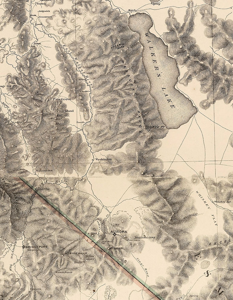
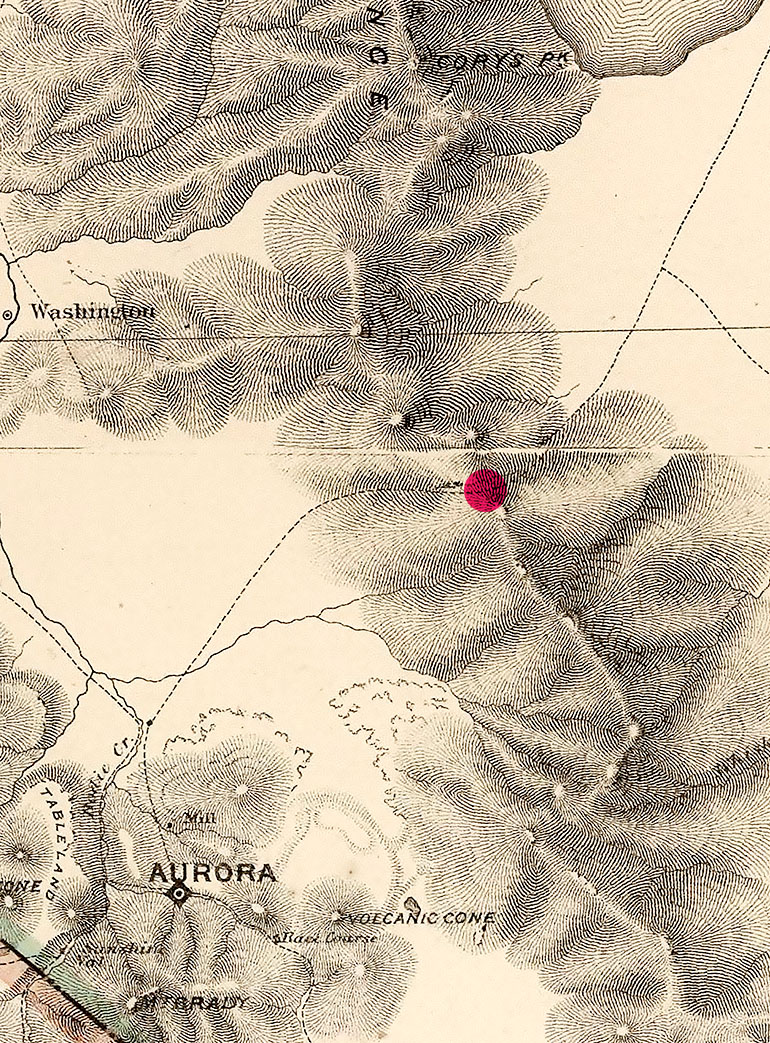
Here’s a closer view (below), with a red dot over Lucky Boy Pass. A few other things to note on this map: the city of Hawthorne (near the south end of Walker Lake) isn’t there yet. Hawthorne was established about 1880. The label “Cory’s Peak” is a little off-target. It’s placed on today’s Mt Grant (highest in the Wassuk Range). Cory Peak should be the first knob north of the red dot. “Mt. Brady”, south of Aurora, is now called Brawley Peaks (although that’s apparently a mis-spelling of Braly). The little back dot at the crossroads north of Aurora marks the stage stop at Fletcher.
The road over Lucky Boy Pass became a main road connecting Hawthorne with points to the west, perhaps during the peak of activity at Aurora (1863-64) and Bodie (mid-1880s). The arrival of the Carson and Colorado Railroad at Hawthorne in 1881 also boosted activity along this road. Today the road is wide and well maintained, having recently served the now mostly inactive Borealis Mine (just south of Lucky Boy Pass) and Esmeralda Mill (just east of Aurora in the Bodie Hills).

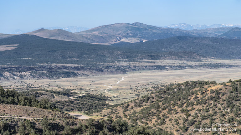
Looking Southeast from near Lucky Boy Pass: Buller Mountain
in the southern Wassuk Range
On a clear day, there are fine views into the remote eastern slopes of the Bodie Hills, and glimpses of the Sierra Nevada beyond.
Looking South: Mt. Hicks (right) and the distant Sierra Nevada (left).
Looking South-southwest: Brawley Peaks near Aurora (center). Fletcher Valley in the foreground, with Mud Spring Wash in front of the dark volcanic flows crossing the middle of the picture.

Looking Southwest: Dunderberg Peak in the Sierra Nevada (center), then Bodie Mountain and Potato Peak in the Bodie Hills (right of Dunderberg). More of Fletcher Valley beyond foothills in the foreground.

The southern portion of the Wassuk Range from Fletcher Valley (looking north). Corey Peak (10,520 ft, right of center) appears to be the highest. Mount Grant (11,239 ft), although taller, is much farther away, barely visible as a low bump left of center. Lucky Boy Pass is near the right edge of this picture.
Lucky Boy Pass Road probably takes its name from the Lucky Boy Mine, discovered in 1908 several miles south of Hawthorne. But who was this lucky person? And what was he lucky with—prospecting, cards, love? I haven’t found the answers, but he appears to have moved around a lot: there are “Lucky Boy” mines in Alaska, Arizona, California, Colorado, Idaho, Montana, New Mexico, Oregon, South Dakota, Utah, and Washington, as well as Nevada.
Copyright © Tim Messick 2016. All rights reserved.
DOWNLOAD THE CHECKLIST

Thanks Tim. Very interesting and I always appreciate that you share your links. Yes, that Lucky Boy did get around!
Thanks, Julie Anne! This was on the day after our Treasure Hunt at Travertine.
Wonderful research and mapping references. I am hoping you might be of help in the identification of this 1920s view of a Nevada Range titled Hawthorn Range. Was the Wassuk mountain range ever referered to as the Hawthorn Range, due to proximity?
The Artist traveled between from Boulder and New Mexico , so might not known exactly what he was looking at.
Sincerely,
William Bock,
(curator The Willard Page Collection, willardpagecollection.com) I can send you an image of the mountain range in question and can be reached at WmBockFineArt@gmail com
Hi, William — Thank you for visiting! Interesting question. I’m not aware of any mountains in the Hawthorne, NV area being called the Hawthorne (or Hawthorn) Range. I have not seen that on any old maps of the area. I did a search on the Geographic Names Information System (GNIS) web site (at https://www.usgs.gov/core-science-systems/ngp/board-on-geographic-names/domestic-names) for both “Hawthorne Range” and “Hawthorn Range” and came up with no results. Which is not to say the name was never used somewhere, but perhaps not in Mineral County.