Monthly Archives: September 2016

Sand Rice Grass

Stipa hymenoides

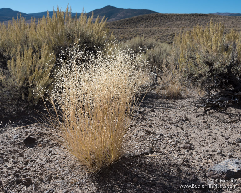
One of my favorite grasses of the Great Basin is the common and widespread sand rice grass (Stipa hymenoides). The rice grasses (or “ricegrasses”) were formerly treated in the genus Oryzopsis, which differed from the closely related needle grasses (Stipa spp.) in part by their short, generally straight and deciduous awns, rather than the mostly much longer, bent, and persistent awns of the needle grasses. Alas, Stipa and Oryzopsis were long known to hybridize promiscuously, and other morphological and developmental studies showed more similarities between the groups, so (to oversimplify the taxonomic story) Oryzopsis was lumped into Stipa. But in common parlance, the shorter-awned taxa are still “rice grasses” and the long-awned taxa are still “needle grasses”.

Stipa hymenoides

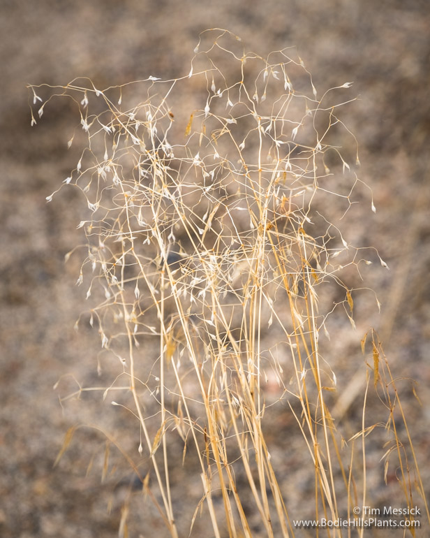
In late summer and fall, the seeds swell and push open the florets, making the plants catch the light especially well, so these bright little bunchgrasses can be seen easily from afar. The plants above, however, were right along the sandy edge of the Sweetwater-Aurora road (NF-028), west of The Elbow in Lyon County, in late September.

Stipa hymenoides

Rice grass seeds, especially those of Stipa hymenoides, are highly edible. Sand rice grass used to be called “Indian rice grass”, which is ethnologically and now also politically incorrect, but the name reflected the fact that the seeds were collected for food by Native Americans. Livestock and wildlife find the plants appealing too.

Stipa hymenoides

Sand rice grass is the official the State Grass of Utah and is planted for land reclamation, habitat improvement, and ornamental purposes. Let there be no confusion, however: “rice grass” is very different from true rice, which is also grass (Oryza spp.), but of tropical wetlands (and widely cultivated).

Stipa hymenoides

Stipa hymenoides, last October, at Lee Vining.


Copyright © Tim Messick 2016. All rights reserved.
DOWNLOAD THE CHECKLIST

Fletcher

Fletcher from the east

Fletcher from the east. East slopes of the Bodie Hills behind.

Fletcher has never been more than a dot on maps of Mineral County (Nevada), but in the late 1860s, when Aurora was a busy mining camp, this little spring-fed oasis at the northern tip of the Aurora Crater lava field became a welcome rest stop on the rough wagon roads from Hawthorne to the east and Carson City to the north.

Fletcher from the west

Fletcher from the west. Corey Peak in the Wassuk Range in the distance.

A plaque in the shade of a tall willow reads: “FLETCHER: Formerly known as Six Mile Station, this stage stop and way station provided service between some of the smaller mining camps and Aurora and Bodie, CA during the late 1860s. The area became of greater importance with the arrival of the Carson and Colorado Railroad in 1881. With increased passenger and freight traffic between Hawthorne, Aurora, and Bodie and the expanding local population, a post office was established on October 24, 1883 and named for H. D. Fletcher, the first postmaster. The post office was removed on November 10, 1918, when Hawthorne became the mailing address for area patrons.”

Plaque at Fletcher

There isn’t much on the internet about the history of Fletcher. You can read a little more here and here.

The spring here is one of the few perennial sources of potable water in the eastern Bodie Hills and in all of Fletcher Valley. It also supports a few acres of wetland and riparian vegetation, so it’s attractive to wildlife. It has probably been attractive to all inhabitants of the region for thousands of years.

The spring at Fletcher.

The spring at Fletcher.

Fletcher

The only remaining structure.

Trees here include four species of Populus: Fremont cottonwood (P. fremontii), black cottonwood (P. trichocarpa), quaking aspen (P. tremuloides), and the non-native Lombardy poplar (P. nigra ‘Italica’). At least two, probably three willows are here, but I need to return for flowering material to key them reliably.

Fletcher

Populus trichocarpa

Fletcher

Populus tremuloides

Fletcher

Meadow and emergent marsh fed by the spring at Fletcher.

Fletcher

Cattails (Typha) at Fletcher.

Fletcher on 1873 Hoffman CalifGeolSurv CentralCA Sheet_II

Fletcher (black dot in yellow circle) on a portion of the 1873 “Topographical Map of Central California Together with a Part of Nevada” [Sheet IV], by Charles F. Hoffman of the California Geological Survey (link to Sheet IV in the David Rumsey Map Collection).

Fletcher on a Nevada DoT highway map

Fletcher (black dot at yellow arrow) on a portion of the 2014 Nevada Department of Transportation “General Highway Map”, Quadrangle 8-10.


Copyright © Tim Messick 2016. All rights reserved.
DOWNLOAD THE CHECKLIST