Category Archives: Botany

Mapping the Varieties of Eriogonum wrightii

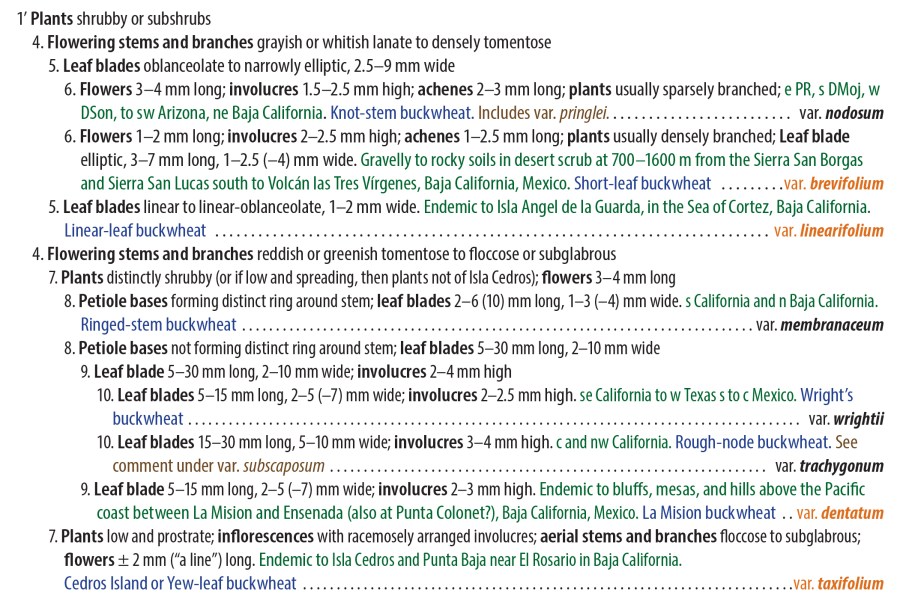
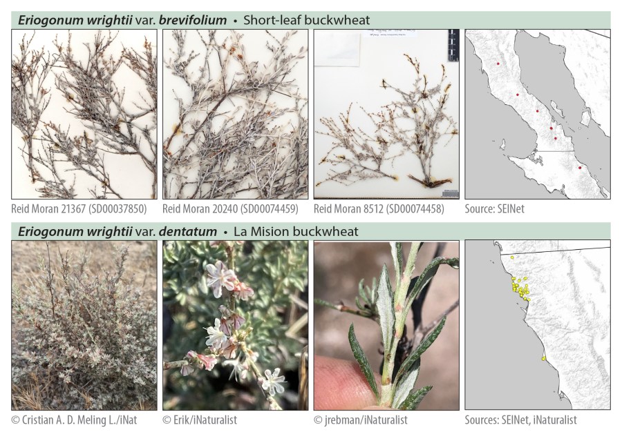
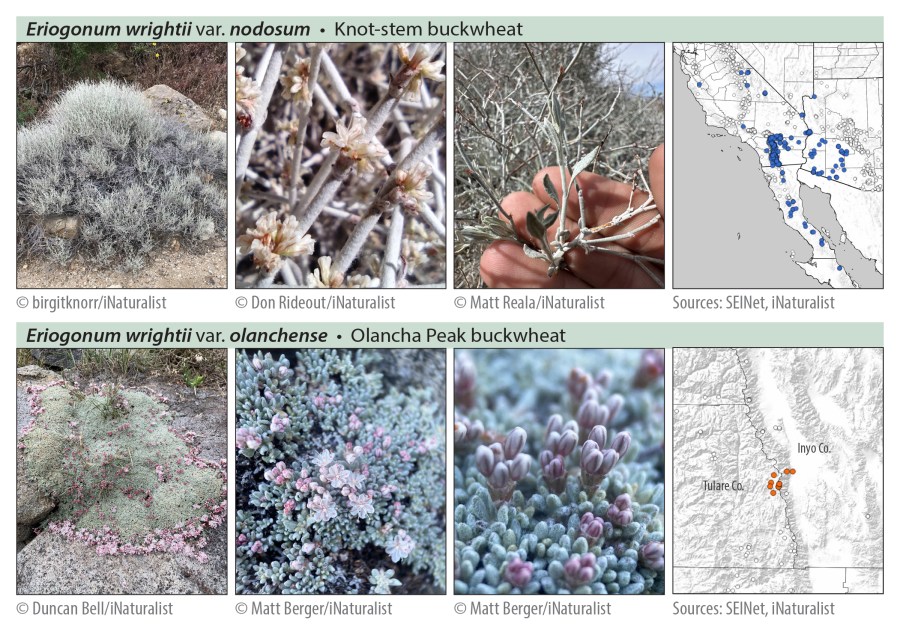
Anyone hiking in the Sierra Nevada eventually encounters Eriogonum wrightii (“Wright’s buckwheat” or, if you must, “Bastard sage”). The common form through most of the high Sierra is variety subscaposum—a short, more or less matted, perennial subshrub, with stems bearing white to pink flowers ascending either from throughout the plant, or often from just around its perimeter. It’s found in the Bodie Hills too, often on moderate to steep scree-like slopes.

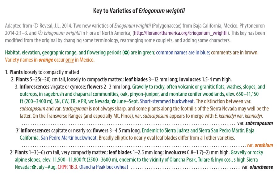
Eriogonum wrightii has 11 varieties in all: 5 occur only in Mexico (mostly in Baja California); the rest occur in the United States, but at least 3 of these extend across the southern border (and have certainly done so since long before there ever was a border). Most plants will run through the key without much difficulty, and some varieties are largely separate from the others geographically. Where taxon ranges may overlap, only 2 or 3 varieties will vie for your attention.

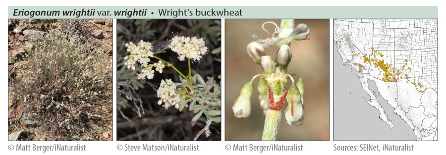
Curious to learn more about the other 10 varieties of E. wrightii and their distribution, I mapped all 11 using herbarium and iNaturalist data. The range maps were produced in QGIS, based on specimen location data in the SEINet Portal Network and iNaturalist observations (“Research Grade” only) as of December 11, 2023. NOTE: Some dots on the maps may be based on misidentifications or mismapped coordinates; most individual data points have not been reviewed to eliminate such errors, so taxon ranges indicated by these maps should be considered approximate.

I also wrote a key, adapted from Reveal 2005 and Reveal 2014. This key has been modified from the originals by changing some of the terminology, rearranging some couplets, and adding some characters. I like my keys to include some of the information traditionally provided separately in descriptions, and I like to use text color to visually “layer” different categories of information. This is what you get when a botanist takes up information design and learns to love Adobe InDesign software.

The photos below are all from iNaturalist, except for a few from herbarium specimens of rarely observed taxa. All the photos are licensed for non-commercial use by the copyright holders under Creative Commons licenses CC BY 4.0, CC BY-NC 4.0, or CC BY-NCND 4.0. Thank you to all the photographers for allowing these images to be used!

References


Copyright © Tim Messick 2024. All rights reserved.

Plants of Hot Springs Valley (2024 Update)

It’s past time for an update to the vascular plant checklist for Hot Springs Valley and Grover Hot Springs State Park, in Alpine County, California. Since the last version of the checklist (November 2018), several plants have been added to the list, based on observations posted to iNaturalist (https://www.inaturalist.org/observations?place_id=127882). The list now includes 348 “minimum rank” taxa (distinct species, subspecies, or varieties) in 64 plant families. The March 2024 version of this checklist (a free 8-page PDF) is available on the Downloads Page.

Some of these additions are a result of disturbance and habitat changes caused by the Tamarack Fire, which burned much of the valley (but not the hot springs, meadows, or campground) in July 2021. Below are two views of the Tamarack Fire perimeter. The first shows the burned area in relation to all of Hot Springs Valley, including Grover Hot Springs State Park; the second is zoomed in to the fire perimeter around the meadows within the main part of the park.

Recent additions to the list of plants here include:

  • Argemone munita (Flatbud Prickly Poppy)
  • Eriogonum umbellatum (Sulfur Buckwheat)
  • Heterotheca orovillosa (Hairy Goldenaster)
  • Mimetanthe pilosa (False Monkeyflower)
  • Nicotiana attenuata (Coyote Tobacco)
  • Ranunculus alismifolius Plantainleaf Buttercup)
  • Solanum xanti (Purple Nightshade)

It will be interesting to continue exploring burned areas and monitoring habitat recovery this year and for some years to come. I was impressed with the abundance of native flora growing in some burned areas (especially near moisture) during my last visit, in June 2023.

Solanum xanti (Purple Nightshade)
Argemone munita (Flatbud Prickly Poppy)

Data source for California Fire Perimeters (updated annually): https://gis.data.ca.gov/datasets/CALFIRE-Forestry::california-fire-perimeters-all-1/explore


Copyright © Tim Messick 2024. All rights reserved.

Plants of the Bodie Hills, 2024 Edition

Plants of the Bodie Hills, 2024 Edition, is now available on the Downloads page (a free PDF). As in previous years, the new edition contains additions, corrections, nomenclatural updates, and refinements to the keys. A key to families of Dicots (Magnoliopsida) in the area has at long last been added. Several place names, road names, and boundaries have been added to the map on the back cover (last page of the PDF).

The total number of “minimum rank” vascular plant taxa documented to occur in the Bodie Hills now stands at 727, in 80 families. Another 96 taxa, including 2 additional dicot families, are still considered to be potentially present, but not yet confirmed by collections or observations within the Bodie Hills.

Below Travertine Hot Springs

New additions to the 2024 edition (found during 2023) are:

  • Lupinus uncialis (Lilliput lupine) at the Bodie Hills Preserve and at Travertine Hot Springs,
  • Micromonolepis pusilla (Dwarf monolepis) at Mormon Meadow,
  • Phacelia curvipes (Washoe phacelia) in the southwestern Bodie Hills,
  • Platanthera tescamnis (Great Basin bog orchid) at a remote spring in the northeastern Bodie Hills in Mineral County, and
  • Saponaria officinalis (Common soapwort) at Conway Summit.

Plants seen in 2023 that had been expected in the Bodie Hills or not seen here for decades were:

  • Antirrhinum (Sairocarpus) kingii (King’s snapdragon) at Travertine Hot Springs,
  • Collomia grandiflora (Large-flowered collomia) near Mormon Meadow,
  • Eriogonum hookeri (Hooker’s buckwheat) at Travertine Hot Springs,
  • Erythranthe rubella (Little redstem monkeyflower) at “Sage Flat,” (near the Little Bodie Mine historical marker),
  • Malacothrix glabrata (Desert dandelion) in Red Creek Wash (from a 1983 collection),
  • Penstemon deustus (Hot rock penstemon) north of Bridgeport Reservoir Dam, and
  • Silene nuda (Sticky catchfly) along Cow Camp Road.

Nearly all of these were found, not by me, but by others posting their observations to iNaturalist (thanks to all who do this!). All observations within the Bodie Hills on iNaturalist can be seen HERE.

Jeffrey and Lodgepole pines in the western Bodie Hills

As before, you have two options for how to use this document: 1) load the PDF onto a mobile device or 2) print the PDF yourself.

  • Using a mobile device: I’ve found the PDF to be quite readable on my iPhone (in the Books app), although it helps that I’m near-sighted. It’s even easier to read on an iPad, other tablet, or laptop.
  • Printing the PDF: You can print the PDF yourself or at a local print shop. I highly recommend printing the 128 pages 2-sided to conserve paper and to reduce bulk and weight in the field. A comb or spiral binding, binder clip, or other binding will hold it together.

Your additions, corrections, comments, or questions are always welcome.

Cliffs above Bodie Creek at the state line

Copyright © Tim Messick 2024. All rights reserved.