Another year has passed and a few more vascular plants have been found or confirmed in the Bodie Hills. Some changes in taxonomy and nomenclature have occurred as well. Here’s a summary of additions and changes based on field observations during 2025 and from recent publications. The page numbers below refer to pages in the 2025 edition of “Plants of the Bodie Hills.” I’m not planning a full new edition for 2026—just this “supplement.”
A printable PDF of this 2026 Supplement, and also the full 2025 edition of Plants of the Bodie Hills (both free PDFs) are available to download at https://bodiehillsplants.com/downloads/.
Highlights: Vascular plant species new to or confirmed in the Bodie Hills in 2025 are: Pinus albicaulis (Whitebark pine), Asclepias speciosa (Showy Milkweed), Geum triflorum (Prairie smoke), Galium aparine (Catchweed bedstraw), Sisyrinchium idahoense (Idaho blue-eyed-grass), and Juncus macrandrus (Long-anthered Rush). Extensive revisions have occurred in the taxonomy of Monardella (the Coyote mints) and Pyrrocoma (the Goldenweeds—a regrettable common name for a genus of native plants that are not weedy).
Additional Notes: While vascular plants have been pretty well documented in the Bodie Hills (though not exhaustively—more are certain to be found or confirmed), other kinds of biodiversity have been only lightly explored, especially mosses, liverworts, fungi, lichens, and nearly all invertebrates. These are more challenging groups, often requiring the aid of a microscope and specialized literature for identifications to species. Nevertheless, they are well worth documenting with observations on iNaturalist and/or specimens in museum or herbarium collections.
Class PINOPSIDA (Conifers)
CUPRESSACEAE, Cypress family
Juniperus (pp. 8–9): Juniperus grandis, (Sierra juniper): Scattered individuals probably occur along with J. osteosperma (Utah juniper) in the northern and western Bodie Hills, notably in the vicinity of Masonic Mountain and in the Aurora Canyon area. A single juniper that appears to be J. grandis has been observed on the south side of West Brawley Peak, possibly (but not completely certain) at 38.243512, -118.923258 (view in the 2/2014 imagery on Google Earth), elevation about 8870 feet. Thanks to Connie Millar and Lynn Boulton for this tip. It would be interesting to visit this remote location (a long cross country hike from anywhere) to check this. A few more widely scattered individuals may be in the area. Although overall appearance often suffices to distinguish Sierra juniper from Utah juniper, close examination of leaf glands and the number of seeds in each berry-like cone will generally clear up any uncertainty.
PINACEAE, Pine family
Pinus (p. 9): Pinus albicaulis (Whitebark pine) is now a confirmed addition to the conifer flora of the Bodie Hills. A small grove occurs at the top of a steep slope, surrounded by a stand of Mountain mahogany, just north of the site of Millersville (a former mercury mining site) north of Potato peak. Many thanks to “glittergravel” on iNaturalist for pushing through dense Mountain mahogany to visit this site (https://www.inaturalist.org/observations/280403230). It seems unlikely that any more Whitebark pines will be found in the Bodie Hills, but it’s always worth looking closely at these isolated relict stands of conifers to see what’s there.
Class MAGNOLIOPSIDA (Dicots)
APIACEAE (UMBELLIFERAE), Carrot family or Umbel family
Perideridia (pp. 16–17): Perideridia gairdneri probably does not occur in or near the Bodie Hills and perhaps not even in the Sierra Nevada, but “Computer Vision” (the AI identification tool in iNaturalist) frequently misidentifies many Perideridia observations as P. gairdneri. Species identifications in this genus are difficult, even with specimens in hand, and especially from photographs, because one usually needs to see the the pattern of divisions in the basal leaves (often obscured by grasses and other foliage), details of the ridges on mature fruits (often not distinct until after the basal leaves have become dry and distorted or absent), and sometimes also the root system (fibrous vs. tuberous). Most observations of Perideridia on iNaturalist show only the inflorescence (an umbel of tiny white flowers), and species can NOT be reliably identified this way. Nevertheless, Computer Vision has been “trained” to identify P. gairdneri largely from photos showing only or mostly the inflorescence, and many of the observations used in that training were likely misidentified. Hence, the great prevalence of misidentifications in Perideridia on iNaturalist.
APOCYNACEAE, Dogbane family
Asclepias (p. 17): Asclepias speciosa (Showy Milkweed) has confirmed along the northwest edge of the Bodie Hills in the East Walker River canyon (iNaturalist observations).
ASTERACEAE (COMPOSITAE), Sunflower family
Agoseris (p. 22): In the 2025 edition I neglected to include the author name for Agoseris retrorsa (Spearleaf Agoseris). This should read: *Agoseris retrorsa (Benth.) Greene. Possibly observed at Sage Flat (https://www.inaturalist.org/observations/195979503), but mature or nearly mature fruits are needed to confirm this.
Pyrrocoma (Goldenweed) (pp. 32–33): This genus has been extensively revised by Guy Nesom and others in a lengthy series of papers published in the online journal Phytoneuron during 2025 (relevant citations below).
- Pyrrocoma apargioides has weathered the changes mostly intact, with only some populations in Tulare, Fresno, and Sierra counties being carved out as new species (P. tularia, P. fresnoa, and P. sierravallis respectively). Some individual occurrences in Mono and Mineral counties may now be a better fit for the new or resurrected species P. prionophylla, P. mineralis, and P. thermolibes. In the Bodie Hills, collections and observations identified in the past as Pyrrocoma apargioides are probably still correctly identified as such.
- Pyrrocoma lanceolata and P. racemosa, however, are no longer recognized in Mono and nearby counties (nor is P. uniflora, previously considered to occur in Long Valley). Pyrrocoma racemosa is now considered a rare species occurring mostly in the vicinity of Eugene in Lane County, Oregon. Pyrrocoma lanceolata now consists of three “population systems” ranging from central Nevada to south-central Oregon, to Colorado, North Dakota, and southern Canada.
New names that apply to collections and observations in the Bodie Hills are:
- Pyrrocoma prionophylla Greene is at hot springs and alkaline meadows throughout northern Mono County and northward to Sierra and Washoe Counties. This may be the most prevalent Pyrrocoma at Travertine Hot Springs, but P. virgata is expected there also.
- Pyrrocoma mineralis Nesom is documented in the eastern Bodie Hills (Mineral County) with a specimen collected “near Aurora [38.29° N, 118.90° W], white-encrusted saline soil, with Chrysothamnus, 6900 ft” on 19 July 1981 by Margaret Williams; elsewhere, it’s known so far from the Glass Mountains and Adobe Valley areas of Mono County, and farther east in southern Mineral and westernmost Esmeralda counties, Nevada.
- Pyrrocoma virgata (A. Gray) Nesom occurs in alkaline meadows, flats and marshes, edges of creeks, lakes, and pools, and along roadsides, mostly in Mono County (Long Valley, Adobe Valley, Mono Basin, Bridgeport Valley, western Bodie Hills), with outliers in Mineral County (eastern Bodie Hills) and Lyon County (Wichman on the East Walker River).
Other “new” species that occur in the region, but probably not in the Bodie Hills include:
- Pyrrocoma peregrina Nesom [in southern Mono County and adjacent Inyo County]
- Pyrrocoma thermolibes Nesom [all within the Long Valley Caldera]
- Pyrrocoma eriopoda Greene [Esmeralda to Pershing counties, Nevada]
- Pyrrocoma sessiliflora Greene [southern Mono (at Fish Slough), Inyo, Esmeralda, Nye, and Churchill counties]
Assuming that P. apargioides, P. mineralis, P. prionophylla, and P. virgata are the only 4 species in the Bodie Hills, the following key (based on Nesom’s descriptions) will (I hope) help to distinguish those, but you can also expect some plants to be ambiguous:
- Heads usually solitary; cauline leaves neither clasping nor sheathing the stem; achenes glabrous . . . . P. apargioides
- Heads usually 2–6 (sometimes many); cauline leaves generally clasping along the lower and/or mid-stem.
- Heads numerous; green patch on phyllaries mostly confined to the deltate apex; inner phyllaries 7–9 mm long; achenes sparsely strigose (hairs short, stiff, adpressed) to glabrate (becoming glabrous) . . . . P. virgata
- Heads usually 2–6 (but sometimes 1 or 7–20+); green patch on phyllaries in the distal 1/3–1/2; inner phyllaries either 11–12 mm long (P. prionophylla) or 6–7.5 mm long (P. mineralis).
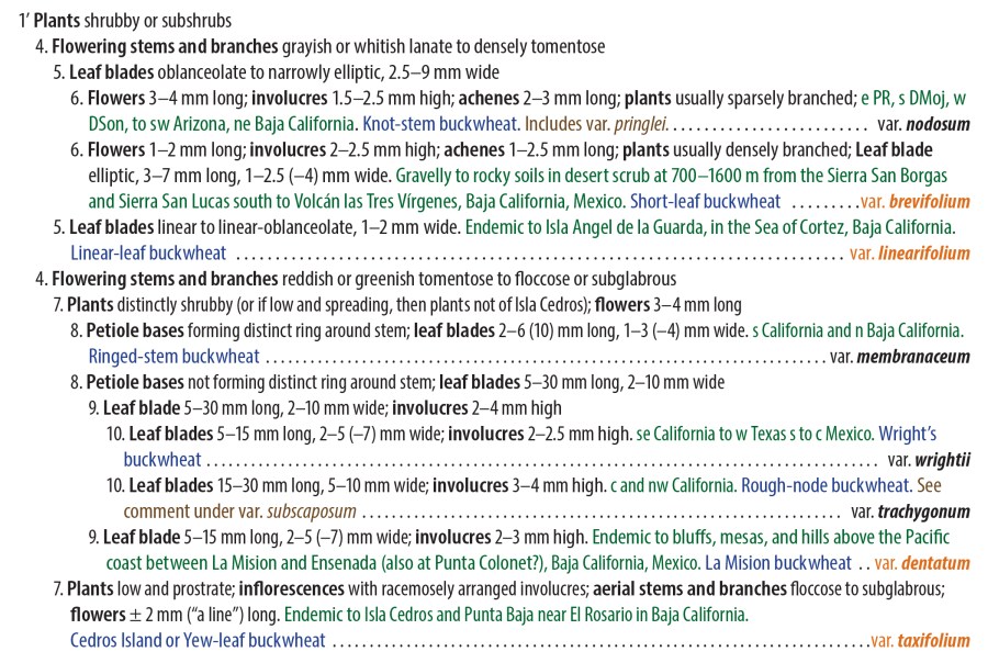
- Inner phyllaries 11–12 mm long; involucres 14–20 mm wide (when pressed); disc corollas 5–7 mm long; lower cauline leaf margins short-ciliate near the base, the cilia sometimes very short (i.e., scabrous-ciliate); basal leaf margins often with a narrow, hardened white rim; achenes glabrous . . . . P. prionophylla
- Inner phyllaries 6–7.5 mm long; involucres 11–14 mm wide (when pressed); disc corollas 4.5–5 mm long; lower cauline leaf margins not ciliate; basal leaf margins consistently entire to minutely denticulate-spinulose, without a hardened white rim; achenes appressed-hairy . . . . P. mineralis
References for Pyrrocoma (see https://www.phytoneuron.net/2025-publications/):
- Nesom, G.L. 2025. Taxonomy of the Pyrrocoma racemosa group (Asteraceae: Astereae). Phytoneuron 2025-08: 1–64. [for P. racemosa]
- Nesom, G.L. 2025. Three species of Pyrrocoma (Asteraceae: Astereae) from east-central California and adjacent Nevada. Phytoneuron 2025-17: 1–35. [for P. prionophylla and P. mineralis]
- Nesom, G.L. 2025. Taxonomy of Pyrrocoma lanceolata (Asteraceae: Astereae). Phytoneuron 2025-31: 1–32. [for P. lanceolata]
- Nesom, G.L. 2025. Pyrrocoma apargioides (Asteraceae: Astereae) and similar species. Phytoneuron 2025-44: 1–55. [for P. apargioides and P. prionophylla]
- Nesom, G.L. 2025. Var. virgata in Pyrrocoma (Asteraceae: Astereae): What it is. Phytoneuron 2025-47: 1–15. [for P. virgata]
- Nesom, G.L. 2025. Nomenclatural summary and synoptic arrangement of Pyrrocoma (Asteraceae: Astereae). Phytoneuron 2025-63: 1–17. [for a full list of all Pyrrocoma taxa]
Solidago (p. 34): In addition to a likely recent occurrence of Solidago multiradiata (Northern goldenrod) at Murphy Spring, this was also recorded at Aurora, NV, in a collection by Mrs. J. D. Wright on 10 July 1930 (SBBG221431: www.cch2.org/portal/collections/individual/index.php?occid=63219). Livestock grazing at meadows and springs may have eliminated or greatly reduced populations in the Bodie Hills.
Sphaeromeria (p. 34): Sphaeromeria potentilloides (=Artemisia potentilloides) (Fivefinger chickensage) has been found at Big Alkali. Thanks to Jaclyn Deloach on iNaturalist for this observation (https://www.inaturalist.org/observations/296860079). It’s been reported (but not yet confirmed) at Travertine Hot Springs. It is known also from Alkali Lake (east of Mt. Hicks) and in similar habitats elsewhere in Mono County (Long Valley, Adobe Valley, and possibly at Fales Hot Springs).
BRASSICACEAE (CRUCIFERAE), Mustard family
Cardamine (p. 45): In addition to the 2007 collection of Cardamine breweri (Bitter cress) at Coyote Spring, this was also observed in July 2025 along the middle reaches of Rough Creek (https://www.inaturalist.org/observations/301842522) by Jordan Collins and Atastra Creek (https://www.inaturalist.org/observations/302418578) by Mike Hine. (Tangential aside: I believe “Atastra Creek” to be a long-perpetuated, never-corrected misspelling of what should have been called Arrastra Creek, because documentation actually exists of an arrastra having been constructed and used—to crush ore—in that area during about 1874–76 … but that’s a story for another time.)
CELASTRACEAE, Staff-vine, Staff-tree, or Bittersweet family
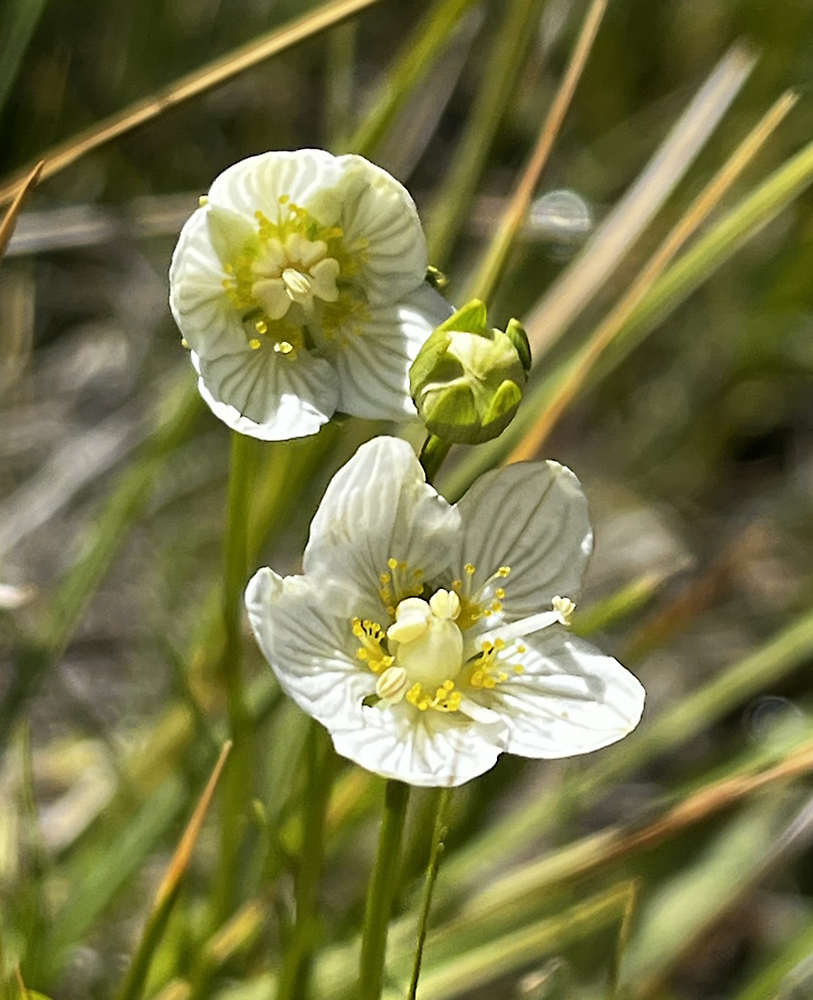
Parnassia (p. 52): Parnassia palustris (Grass-of-Parnassus) was also observed in 2025 by Mike Hine (https://www.inaturalist.org/observations/302418330) near the same location as in 2024 (https://www.inaturalist.org/observations/232424497).
FABACEAE (LEGUMINOSAE), Legume or Pea family
Lupinus (pp. 61–62): Lupinus argenteus var. heteranthus (Silvery lupine) is treated by Plants of the World Online (POWO) and therefore by iNaturalist as a synonym of Lupinus caudatus ssp. caudatus (Tailcup Lupine); however, the Jepson eFlora and Flora of North America do the opposite. “Lupinus argenteus var. heteranthus” thus seems for now to be the name favored by western American authors studying the genus.
LAMIACEAE (LABIATAE), Mint family
Monardella (pp. 66–67): Section Ovata of Monardella (Pennyroyal) was revised in a 2022 study by Mark Elvin et al. (citation below). The Jepson eFlora has not (yet?) adopted their changes, and the Flora of North America volume including Monardella is still in preparation. Following the Elvin et al. treatment, plants in the Bodie Hills would likely be Monardella rubella Greene rather than M. odoratissima. The study concluded that the M. odoratissima complex is restricted to central and northeastern Washington, adjacent southern British Columbia, and along the southern banks of the Columbia River in central northern Oregon. Plants throughout the Sierra Nevada previously called Monardella odoratissima should instead be called M. ovata; those in and near Mono County all or mostly subsp. pallida. Plants in the Bodie Hills are probably best placed in M. rubella. Elvin et al. 2022 do not provide a dichotomous key for these or other species of Monardella, but utilizing their “Table 1. Comparison of characters …”, the following couplet should separate M. ovata subsp. pallida and M. rubella:
- Stems 20–25 cm long; leaves 25–30 mm long, 6–7.5 mm wide, adaxial (upper surface) pubescence sparse to moderately dense; petioles 3–4.5 mm long; bracts 12–15 mm long, 5.5–9 mm wide; calyx 8–10 mm long, pubescence on teeth moderately dense (probably the typical Monardella in the Bodie Hills) . . . . M. rubella
- Stems 25–35 cm long; leaves 30–40 mm long, 8–12 mm wide, adaxial pubescence subglabrous to sparse; petioles 5–11 mm long; bracts 6.5–7 mm long, 3.5–4.5 mm wide; calyx 5.5–6.5 mm long, pubescence on the teeth dense to very dense (mostly in the Sierra Nevada; perhaps not in the Bodie Hills) . . . . M. ovata subsp. pallida
Reference: Elvin, Mark A. , Ronald B. Kelley, and Bryan T. Drew. 2022. Vegetative and Trichome Morphology Distinguish the Monardella ovata Species Complex from the Monardella odoratissima Species Complex: Taxonomic Studies in Monardella (Lamiaceae) VII. Systematic Botany (2022), 47(3): pp. 697–715. Available at: https://www.researchgate.net/publication/364331835.
RANUNCULACEAE, Buttercup family
Ranunculus (pp. 93–94): Ranunculus aquatilis (Aquatic buttercup) in this area is probably R. longirostris (Longbeak Buttercup) instead. In the current (as of February 2026) treatments of Ranunculus in Flora of North America (1997) and in Jepson eFlora (2012), the plants in the Bodie Hills key to Ranunculus aquatilis var. diffusus, with R. trichophyllus and R. aquatilis var. longirostris among the synonyms. A more recent (2017) treatment of Ranunculus section Batrachium (the Water-Crowfoots) by Gerhard Wiegleb et al. and very recent comments on iNaturalist by Wiegleb (as naturalist89577) indicate plants in the Bodie Hills and in much of the Intermountain region are best recognized as R. longirostris. Plants in this area have capillary leaves only (no laminar leaves), which rules out R. aquatilis. Other floral and leaf characters rule out R. trichophyllus.
Wiegleb noted (on 12 October 2024) in iNaturalist (https://www.inaturalist.org/observations/230033748) that “R. longirostris differs in 3 characters from all other species of the section (the long styles, the 3-dimensional round-conical nectar pit, the specific branching pattern) and is genetically distinct (separate clade opposed to all other species)” and that “It shows an enormous phenotypic variation with respect to flower color, leaf structure and length, petal number and size etc. But all these morphotypes share the above 3 key characters.” The 2017 paper includes a key to species, though subsequent studies have probably clarified some details yet to be incorporated into a newer key.
Reference: Wiegleb, G., J. Z. Gałosz, and A. A. Bobrov. 2017. A taxonomic account of Ranunculus section Batrachium (Ranunculaceae). Phytotaxa 319 (1): 1–55. Available at https://www.researchgate.net/publication/319416275_A_taxonomic_account_of_Ranunculus_section_Batrachium_Ranunculaceae.
ROSACEAE, Rose family
Geum (p. 95): Geum triflorum (Prairie smoke) was observed at about 8750 feet along the road from New York Hill south onto Masonic Mountain in June 2025, and is a new addition to the flora of the Bodie Hills. Thanks to Rachel Maria Condon for her observation at https://www.inaturalist.org/observations/336061962. Geum macrophyllum has already been documented several places in the Bodie Hills. The two can be distinguished as follows (adapted from the Jepson eFlora):
- Style in fruit 15–40 mm long, plumose, not or inconspicuously hooked; flowers nodding, ± cup-shaped; petals cream to pale yellow, pink-tinged or purple-veined, persistent; hypanthium bractlets 5–15 mm long . . . . G. triflorum var. ciliatum
- Style in fruit 2–9 mm long, not plumose, hooked; flowers generally erect, rotate; petals yellow, deciduous; hypanthium bractlets generally absent, or at most 2 mm long . . . . G. macrophyllum var. perincisum
RUBIACEAE, Madder family
Galium (p. 97): Galium aparine (Catchweed bedstraw or Goose grass) is a probable new addition to the flora, from an observation by Connie Rutherford along the East Walker River (https://www.inaturalist.org/observations/304889463). Among other bedstraws in the area, it’s most similar to G. bifolium (both are trailing annuals with hooked hairs on their fruits), but G. biflorum has leaves in whorls of 4, in 2 unequal pairs, and generally 3 corolla lobes, whereas G. aparine has leaves in whorls of 6–8, and generally 4 corolla lobes. The Jepson eFlora identifies G. aparine as native, though it becomes very aggressively weedy in urban gardens and greenbelts.
Another species, Galium stellatum (Starry bedstraw), is not expected in the Bodie Hills, but is often mistaken for G. multiflorum (Kellogg’s bedstraw), which is the most common Galium in this area. Galium stellatum is prevalent well south of the Bodie Hills in the Mojave Desert, and at lower elevations (below about 5250) feet, to southern Nevada, much of Arizona, and northwestern Mexico. The two can be distinguished as follows (adapted from the Jepson eFlora):
- Stems 15–35 cm tall, woody only at base; largest leaves 8–15 mm long, widely ovate to round; inflorescence a terminal panicle; elevation generally > 4250 ft. (common in the Bodie Hills) . . . . G. multiflorum
- Stems 30–90 cm tall, woody at and above base; leaves generally 4–8(–20) mm long, lanceolate to needle-like; inflorescence of axillary panicles; elevation generally < 5250 ft. (not expected in the Bodie Hills) . . . . G. stellatum
Class LILIOPSIDA (Monocots)
IRIDACEAE, Iris family
Sisyrinchium (p. 110): Sisyrinchium idahoense (Idaho blue-eyed-grass) appears to have been found below a spring on an unnamed tributary south of Aurora Canyon https://www.inaturalist.org/observations/301541506. Thanks to Jordan Collins for posting this observation, in which it appears that the outer bract of the inflorescence is substantially longer than the inner bract—a good indication that this is S. idahoense, rather than S. halophilum.
JUNCACEAE, Rush family
Juncus (p. 111): Juncus macrandrus (Long-anthered Rush) appears to have been confirmed in the Bodie Hills at https://www.inaturalist.org/observations/302424919. Thanks to Mike Heine for posting this on iNaturalist. This observation is west of Dry Lakes Plateau, along Atastra Creek.
POACEAE (GRAMINEAE), Grass family
Crypsis (p. 117) has been submerged into Sporobolus in the Jepson eFlora (revision 15, Feb 2025), so that Crypsis alopecuroides has become Sporobolus alopecuroides (L.) P.M. Peterson. In the Flora of North America, Crypsis is still treated separately.
Copyright © Tim Messick 2026. All rights reserved.