Tag Archives: California

Cacti of the Bodie Hills

The cacti of the Bodie Hills are not difficult to master. There are only two of them: a Prickly-pear and a club-cholla. Opuntia polyacantha and Grusonia pulchella are both in subfamily Opuntioideae, and Grusonia was formerly included in the mega-genus Opuntia. That large and diverse genus is now treated in Flora North America and the Jepson eFlora as several separate genera. This isn’t just fine-grained splitting; Opuntia is still large, and the other smaller genera are easily distinguished in the field based on the shape of stem segments, overall growth form, and the presence or absence of spine sheaths. All Opuntioid cacti are armed with two kinds of spines: large, smooth, fixed spines and small, hairlike prickles called glochids, that will easily (and painfully) detach from the plant and penetrate your skin.

Key to Cactaceae in the Bodie Hills
1. Stem segments bilaterally flattened, circular, ovate, or obovate; flowers yellow to greenish-yellow;
throughout the Bodie Hills. . . .  Opuntia polyacantha
1’ Stem segments cylindric to ± spheric; flowers rose to purple;
north and east foothills of the Bodie Hills. . . .  Grusonia pulchella

Opuntia polyacantha

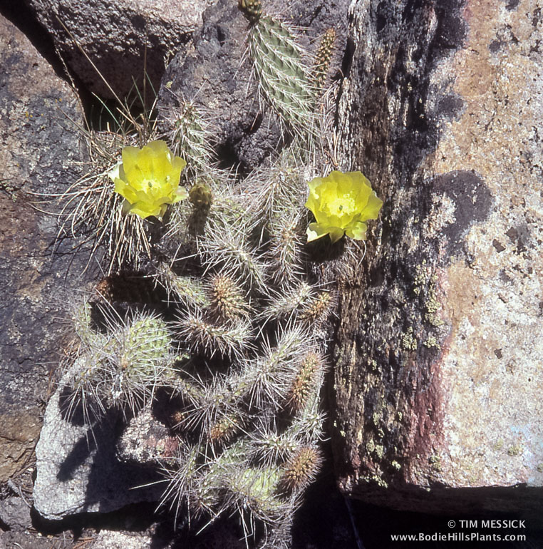
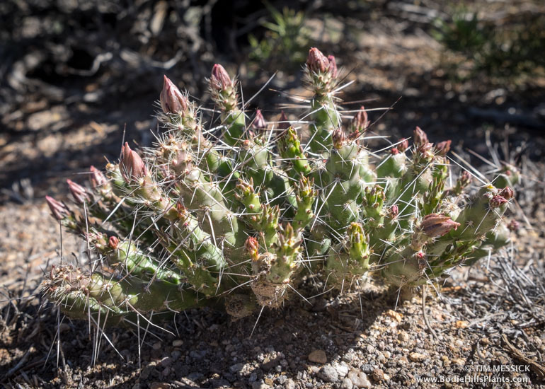
Opuntia polyacantha (above) is a prickly-pear cactus densely clothed in long spines. Common names include Grizzly bear prickly-pear, Mojave prickly-pear, and Plains prickly-pear, and (probably in Texas and Oklahoma) Panhandle prickly-pear. In the Bodie Hills, it’s fairly common on rocky outcrops, talus slopes, and occasionally among sagebrush. The plants are usually widely scattered, never numerous in one location.

This is a very widespread species (in virtually all of the western U.S. and Canada, plus scattered counties as far east as Missouri). There are several varieties. O. p. var. erinacea is the one commonly encountered throughout the Bodie Hills and across the Great Basin, Colorado Plateau, and Mojave Desert. One collection in 1945 (UC733179: Roxana S. Ferris and Laura Lorraine, 11027) from the New York Hill area—part of Masonic Mountain—was identified as O. p. var. hystricina. This could be accurate, but ought to be checked in the field. Var. hystricina (“Porcupine prickly-pear“) occurs mostly in southern Utah and nearby areas of adjoining states.

Grusonia pulchella

Grusonia pulchella (above) is a club-cholla that also has long spines, but generally less dense than in the Opuntia. Common names include Beautiful club-cholla and Sagebruch cholla. This plant “differs from other North American Opuntioid cacti in having a geophytic habit, where above-ground growth dies back to the crown in adverse conditions, and resprouts under more favorable conditions.” Here are some other photos of it, in flower.

Grusonia pulchella is found through much of the Great Basin, mostly in Nevada and Western Utah. In California it is recorded only from Deep Springs Valley in Inyo County. In the Bodie Hills, all occurrences are probably in Nevada.


Copyright © Tim Messick 2015. All rights reserved.

New Bodie Hills Geology Map from USGS

The U.S. Geological Survey has just published a detailed and beautiful new full-color “Geologic map of the Bodie Hills, California and Nevada.” The map can be downloaded for free, here: http://pubs.usgs.gov/sim/3318/. Map Sheet 1 is the map itself, and Map Sheet 2 is the explanation of map units. Several other files provide related information.

The Bodie Hills are mostly Miocene and Pliocene volcanic and sedimentary rocks, with a variety of Quaternary surface deposits. Granitic basement rocks, mostly Cretaceous and Jurassic, are prominent in the Masonic Mountain, Aurora Peak, and Rattlesnake Gulch areas. As a teaser, here’s a small part of the map, showing the Aurora–Brawley Peaks area.

Geology map screenshot

Full citation: John, D.A., du Bray, E.A., Box, S.E., Vikre, P.G., Rytuba, J.J., Fleck, R.J., and Moring, B.C., 2015, Geologic map of the Bodie Hills, California and Nevada: U.S. Geological Survey Scientific Investigations Map 3318, 64 p., 2 sheets, scale 1:50,000, http://dx.doi.org/10.3133/sim3318.

Mapping the Bodie Hills

Map-making is a big part of my day-job (at ICF International in Sacramento). I’ve loved detailed maps since I was a kid, especially maps of wild places in the mountains and deserts of California and elsewhere. So naturally, I want to make a nice map of the Bodie Hills. Several others exist already (see links below), but I want to make my own for this book on the plants. Here’s a current (March 2015) draft of the map, and below are some notes on how it was made.

Map of the Bodie Hills and Vicinity

The Bodie Hills and Vicinity (click to enlarge in a new tab)


This map was built in Adobe Illustrator, with help from Adobe Photoshop and two great cartographic plug-ins: MAPublisher for Illustrator, and Geographic Imager for Photoshop, both from Avenza Systems in Toronto.

The shaded relief background was created using digital elevation models (DEMs) from the The National Map. DEMs are a special image format wherein darker pixels represent lower elevations and lighter pixels represent higher elevations. Geographic Imager enables Photoshop to interpret this as a shaded relief image with the light source set to any angle and elevation. Geographic Imager also lets you create custom color gradients to help distinguish low, middle, and high elevations within the map area.

The roads, water features, and boundaries on the map were added using georeferenced vector data (shape files and KMZs) downloaded from various on-line sources of GIS data. Some of this was organized and edited in Google Earth Pro. These data and the georeferenced shaded relief image were all brought together using MAPublisher, which turns Illustrator into a very functional and designer-friendly Geographic Information System — a really nice tool for cartography. The labels were all added in Illustrator, which gives you complete control over the appearance of text and other artwork.

I mentioned there are some other good maps of the Bodie Hills, and here they are:

1) The Bodie Hills Map (by Tom Harrison Maps)

2) The US Geological Survey 7.5-minute topographic quadrangles for the Bodie Hills are (in the red outline with bolded names):

Map_Downloader_990

These can be downloaded for free from the USGS Map Store Map Locator & Downloader page. This is a great resource, but it’s a little complicated. On the Locator Map (see the screenshot above), zoom in to the area north of Mono Lake, select the “Mark Points” mode, click on a quadrangle to make a red pin appear, then click on the pin to get a list of available maps. Scroll through the list (which is in descending chronological order), and click on the file size in the “Download” column to start downloading a PDF of the selected map. The newest maps are very recent. The oldest are less detailed and cover larger areas, but are more than a century old—interesting to compare with today’s roads, towns, and place names.