Tag Archives: Mono County

Lichens of the Bodie Hills (1)

You can’t wander far in the Bodie Hills without noticing some of the colorful lichens growing on rocks throughout the area. Look closer, and you will see a wide variety of shapes and colors, including some that are inconspicuous at first glance. Nearly all of the lichens in the Bodie Hills are saxicolous (they grow on rocks).

These are some of the lichens found in the Chemung Mine area on the north side of Masonic Mountain—a place where both the flowering and non-flowering floras seem particularly diverse and colorful.

TCM-23477-lichen

Gold cobblestone lichen, Pleopsidium flavum.

Acarospora rosulata

A brown cobblestone lichen, Acarospora (probably) rosulata.

TCM-23511-lichen

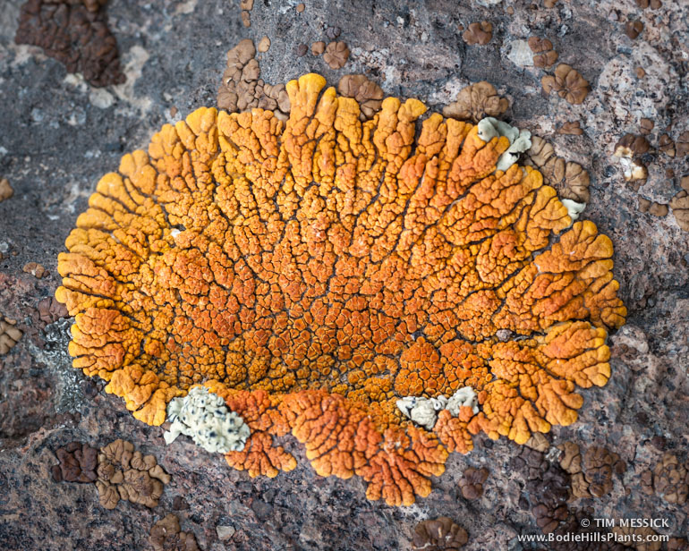
Desert firedot lichen, Caloplaca elegans

TCM-23514-lichen

Green rock-posy, Rhizoplaca melanophthalma, is one of the most abundant
and widespread lichens in the Bodie Hills.

Rhizoplaca spp.

Two kinds of “rock-posy”: Rhizoplaca melanophthalma (left)
and Rhizoplaca chrysoleuca (right).

Lecanora garovaglii

Sagebrush Rim-lichen, Lecanora garovaglii (I think).
TCM-23469-lichen

A rock tripe, Umbilicaria polaris.

Lichen identification gets fairly technical, involving color tests using various chemicals, and microscopic examination of the spores. But a couple of lavishly illustrated books are now available to help the non-specialist identify many lichens from photographs, macroscopic features, and descriptions:

Lichens of North America, by Irwin Brodo, Sylvia Sharnoff, and Stephen Sharnoff. Yale University Press, 2001. (links: Yale U. P. and Amazon)

A Field Guide to California Lichens, by Stephen Sharnoff. Yale University Press, 2014. (links: Yale U. P. and Amazon)

Other good visual resources include Stephen Sharnoff’s on-line lichen gallery and the lichen groups on Flickr, including Lichen Communities of North America, and Lichen.


© Tim Messick 2015. All rights reserved.

Where is Millersville?

While researching old collections of plants in the Bodie Hills (using Calflora and the Jepson eFlora), I’ve run across two collections that were made “northeast of Millersville.” These include specimens of Salix geyeriana (Geyer’s willow) and Polygala intermontana (Great basin milkwort), collected by G. A. Graham in August–September, 1937. (See CalPhotos for pictures of the willow and the milkwort.)

Where’s Millersville?? I reviewed recent maps of the area (for the umpteenth time), did some searching in Google, and looked for place marks in the Google Earth Community. No luck. There’s a Millersville in Kern County, and a few Millersvilles in other states, but no Millersville in or near the Bodie Hills.

Then I happened to be browsing the 1909 Bridgeport 30-minute topographic quadrangle. And there it was, at the end of a dirt road, overlooking Bridgeport Valley, just north of Potato Peak.

Millersville on 1909 Bridgeport quadLooking at the area today, in Google Earth, I see the scars of old prospecting activity (cinnabar mining at the “Alta Plana prospect”, not sure when), some colorful geology, and not far away, some nice stands of trees—perhaps mountain mahogany (Cercocarpus ledifolius), and a small stand of something else—perhaps limber pine (Pinus flexilis).  Must go there.

Google Earth view of MillersvilleMillersville from the west, in Google Earth

New Bodie Hills Geology Map from USGS

The U.S. Geological Survey has just published a detailed and beautiful new full-color “Geologic map of the Bodie Hills, California and Nevada.” The map can be downloaded for free, here: http://pubs.usgs.gov/sim/3318/. Map Sheet 1 is the map itself, and Map Sheet 2 is the explanation of map units. Several other files provide related information.

The Bodie Hills are mostly Miocene and Pliocene volcanic and sedimentary rocks, with a variety of Quaternary surface deposits. Granitic basement rocks, mostly Cretaceous and Jurassic, are prominent in the Masonic Mountain, Aurora Peak, and Rattlesnake Gulch areas. As a teaser, here’s a small part of the map, showing the Aurora–Brawley Peaks area.

Geology map screenshot

Full citation: John, D.A., du Bray, E.A., Box, S.E., Vikre, P.G., Rytuba, J.J., Fleck, R.J., and Moring, B.C., 2015, Geologic map of the Bodie Hills, California and Nevada: U.S. Geological Survey Scientific Investigations Map 3318, 64 p., 2 sheets, scale 1:50,000, http://dx.doi.org/10.3133/sim3318.