Tag Archives: Bodie Hills

Another Swarm of Quakes

Late last December, three moderate earthquakes hit Fletcher Valley and rattled much of the eastern Sierra Nevada. An historic stone building at Ninemile Ranch was seriously damaged, and brick walls all around Bodie were tested for their strength. Every day since that event, very small aftershocks have continued to jiggle the valley east of the Bodie Hills.

2017-04-14 Fletcher quakes map

This week, another concentrated swarm of very small quakes (magnitude 0.1 to 2.6) has appeared under Alkali Valley, about 10 miles southeast of the Fletcher Valley epicenters, just east of Mt. Hicks, at the eastern corner of the Bodie Hills. The aftershocks have been tapering off in Fletcher Valley (only 28 in the last 7 days), but Alkali Valley has felt 120 tremors in just the last 2 days. The maps above and below are from the US Geological Survey’s “Latest Earthquakes” web map of the area (to which I’ve added some place names).

2017-04-14 Fletcher quakes context

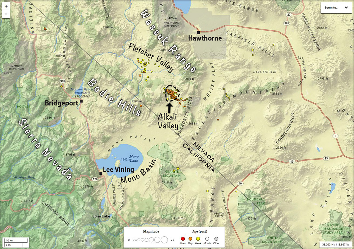
Will Alkali Valley experience a stronger event soon—one that people in the area could actually feel? Maybe not. We’ll see. The region east of Mono Lake and the Bodie Hills is part of a seismically active region along the west edge of the Great Basin, known as the Walker Lane. Just 4 miles north of the Alkali Valley tremors is the most recent volcanic feature adjacent to the Bodie Hills—the late Pleistocene (less than 100,000 years old) trachyandesite lava dome of Mud Spring. Earlier in the Pleistocene, Lake Russel (the much larger ancestral Mono Lake) actually overflowed northward from what is now Alkali Valley, into Fletcher Valley and the East Walker River. Volcanism and uplift in the Mount Hicks area eventually raised the outlet higher than the fluctuating lake level, and a different spillway developed later, southeastward into Adobe Valley.

This is an actively evolving terrain, even on a human timescale. That’s just one of the reasons I love the Great Basin and eastern Sierra Nevada landscape.

UPDATE a week later: 204 quakes in the Alkali Valley area during the last 7 days. The strongest, magnitude 3.1.


Copyright © Tim Messick 2017. All rights reserved.
DOWNLOAD THE CHECKLIST

A Fen in the High Desert

Cinnabar Canyon Bog

There’s a tiny fen (about one-half acre in area) within a somewhat larger meadow (about 1 acre) in Cinnabar Canyon in the Bodie Hills. The most abundant and characteristic plant in this meadow is a Sphagnum, or peat moss (possibly S. fimbriatum, but this needs to be checked using the most recent keys). The peat growth is deep and spongy wet, even late into the dry season. It’s a “mound fen” — water seeps slowly from a spring at the highest point in the meadow. Vascular plants in the meadow include abundant Nebraska sedge (Carex nebrascensis) and Tufted hair grass (Deschanpsia cespitosa), with a few very scrawny Swamp laurel (Kalmia polifolia) plants. The Kalmia was probably more robust and much more at home here during the cooler climate of the Little Ice Age (circa 1300 to 1850).

Cinnabar Canyon Bog

Sphagnum sp.

Cinnabar Canyon Bog

Kalmia polifolia

Cinnabar Canyon Bog

Carex and Deschampsia

This place fills me with questions, but skimming through the on-line literature about peatlands in the Great Basin and Sierra Nevada reveals very few answers.

Cinnabar Canyon Bog

Why is this bog here? What is it about the geology, hydrology, or history if this place that led to the formation (or persistence?) of a fen here, and not in any number of other seemingly similar meadows? Why aren’t there more peaty wet meadows in the Bodie Hills? (There is a suggestion in the literature of just one other that I haven’t seen, near Dry Lakes Plateau.)

Cinnabar Canyon Bog

How long has the fen been here? Peat deposits at other locations in the Great Basin and beyond (some actively growing, some not) have been examined to determine the relative abundance of different kinds of pollen and diatoms at various depths. The peat deposits can be dated at various depths with the aid of identifiable volcanic ash layers. These findings are used to infer changes in vegetation and climate over centuries or millennia. I’m not a palynologist, but I would love to know what a few core samples might tell us about the history of this place.

Cinnabar Canyon Bog

Are there invertebrates that favor these acidic fens, and are they present here? Is there anything unusual about the chemistry of the water in this spring? The water feels cold, but how does the hydrology of this meadow relate to the band of hydrothermal activity (some still active, some long dormant) extending from roughly Cinnabar Canyon northwest to Travertine Hot Sprigs, near Bridgeport?

Cinnabar Canyon Bog

The spring

Unfortunately, the meadow is not in the best of shape. I wish it could be fenced. Trampling by sheep has disturbed the surface and shallow subsurface of the growing peat layer. (But it looked about the same 35 years ago.) This trampling probably reduces the abundance of some plants, degrades the habitat for some invertebrates, and introduces nutrients unfavorable to some of the flora and fauna here.

Cinnabar Canyon Bog

Trampled peat


Copyright © Tim Messick 2017. All rights reserved.
DOWNLOAD THE CHECKLIST

Food of the Gods in the Bodie Hills

How can a scrawny plant, growing in disturbed soils, with painfully sharp spines all over its fruits come to be named  for the mythical “food of the Greek gods”—Ambrosia—a name also related, apparently, to the Greek word for immortality, αθανασία (athanasia)? Carl Linnaeus himself, the “father of modern taxonomy,” bestowed the name in 1754. But why Ambrosia? I haven’t found an explanation. The authoritative Flora North America says “allusion unclear.” One might say it’s a crusty old botanist’s joke on posterity, but I won’t impugn the intentions of the great Linnaeus. The genus isn’t native to Sweden and he may have examined only a few specimens from North America (collected by others). Maybe they smelled nice, but he probably didn’t get to know the genus well enough.

Ambrosia

Ambrosia acanthicarpa, annual bur-weed or annual ragweed, grows on disturbed, sandy soils, often along roadsides, throughout much of western—especially southwestern—North America. The plants seen here were on a dirt road near the north edge of the Bodie Hills, in Lyon County, Nevada. I’ve also seen it beside Hwy 270 at Mormon Meadow and I’ve probably overlooked it at other locations. (Though you’re not likely to overlook it if you encounter it while wearing open-toed sandals.)

It’s not immediately obvious, but Ambrosia is a composite—in the sunflower family (Asteraceae). There are more than 40 species of Ambrosia in the New World, mostly in western North America. Ambrosia now includes plants formerly placed in Hymenoclea and Franseria.

Ambrosia

Despite its vicious demeanor, Ambrosia has an intriguing anatomy. The male flowers, bulging with stamens, are tightly clustered into numerous small heads, dangling along the axis of a tall raceme. The pollen shed from those anthers causes agonizing irritation of eyes and sinuses in anyone getting a face-full of the stuff. Magnified, the pollen grains look like lethal medieval weapons.

ambrosia_artem-wikipedia

While the male flowers will insult your eyes and upper respiratory system, it is the female flowers that will draw blood from your toes and fingers. Pistillate flowers are in the axils of leaves below the staminate inflorescence—the better to catch those heavily armed pollen grains. They lack corollas and are encased, usually one at a time, in a long-spined “bur.” (These spines are derived from the paleas—in Asteraceae, the usually very thin, papery, scale-like or bristle-like “chaffy bracts” at the base of each flower.)  As the fruit matures, the bur becomes very hard. The spines stiffen and become very sharp.

Ambrosia

Did you notice the tire tracks in the first photo? Above you see evidence for one of this plant’s long-range dispersal mechanisms. The mature burs attach themselves freely to automobile tires. No doubt this is one reason Ambrosia acanthicarpa is fairly common along disturbed road shoulders and many lesser-used unpaved tracks throughout the American west.


Copyright © Tim Messick 2017. All rights reserved.
DOWNLOAD THE CHECKLIST